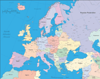
Europe Map with European Union Members

Click for Large Preview
Europe Map with European Union Members
Price
$14.99
€13.94 (EUR) £11.99 (GBP) $20.54 (CAD) $22.63 (AUD)
Updated 5/6/2024 7:50:03 PM. Currency conversions subject to change.
Adobe Illustrator (.ai) and PDF (.pdf) [editable vector format]
Instant download of compressed ZIP archive containing both Adobe Illustrator and PDF map files.
Add to Shopping Cart
Features / Layers on This Map
- Border & Scale
- Hydro Text
- Capitals Text
- Country Text
- Cities 100,000+ Population
- Cities 250,000+ Population
- Cities 500,000+ Population
- Cities 1 Million+
- Cities 5 Million+
- Capitals
- EU Member Countries
- Countries Outline
- Lakes & Rivers
- Countries Fill
- Oceans
Product Description
This Europe Map with European Union Members has all the features of the Europe Map with Countries, Capitals and Cities, but also includes a separate layer containing the political boundaries of European Union (EU) members. The Europe Map with European Union Members is a fully editable, layered Adobe Illustrator file. Adobe Illustrator files are vector format files, allowing for crisp, high-quality artwork at any magnification. All major map objects / features reside on their own layer. For a complete listing of objects/layers, refer to the list in the sidebar.

European Union (EU) Layer (political boundaries turned off)
Political Borders Layer (country fills turned on, EU layer turned off)
This map is also delivered as a fully-editable Adobe PDF map file. This raw PDF file can be opened using the free Adobe Reader software, which allows you to zoom into any portion of the map while maintaining crisp lines and text at any level of magnification. All of our Adobe PDF map files can be easily incorporated into a wide range of other software products, such as Microsoft Word and PowerPoint, as well as Adobe Photoshop and Illustrator. Our PDF maps are also 100% editable in Illustrator 10 and higher, allowing you to select and edit any object on the map (such as state/county/country boundaries, road lines, map symbols, text, etc.). All major map objects reside on their own intuitively labeled layers, allowing you to easily show/hide, edit and delete each main map object. For a complete list of features/layers, refer to the list in the sidebar.
Related Editable Vector Maps
Europe Map with European Union Members
Price
$14.99
€13.94 (EUR) £11.99 (GBP) $20.54 (CAD) $22.63 (AUD)
Updated 5/6/2024 7:50:03 PM. Currency conversions subject to change.
Adobe Illustrator (.ai) and PDF (.pdf) [editable vector format]
Instant download of compressed ZIP archive containing both Adobe Illustrator and PDF map files.
Add to Shopping Cart


